Big trip to Canada. Day 28-30

Friday-Sunday August 8th-10th:

As the crow flies it was over 30+ miles from Reid Harbor to Port Townsend, so the fleet was up and heading south by 5:30am. The fleet consisted of Palarran, Ghost, Pearl, two other boats in the harbor and another boat that joined us as we were passing Roche Harbor. We were all headed to Port Townsend to attend the Lats & Atts Northwest cruisers party for the weekend.

The wind was up and blowing pretty good, unfortunatly it was out of the Southeast, which was the direction we needed to go. At first we thought we would just motor into it and just get to Port Townsend, but the waves were getting pretty big and it was getting old slamming into them all morning. So we raised the sails and did what sail boats do……sail. We had a pretty good sail and some fun with a little tacking duel between us, Pearl and that last boat to join the fleet. Ghost and the other boat motored on without us.

Just as we were passing Lime Kiln Point on the southern end of San Juan Island, Pearl and the other boat took a tack out. We stayed on our tack to hug the coast of the island. Since it was taking pretty close to our rhumbline. This turned out to be the wrong thing to do. About 20 minutes later, the tide turned and the wind dropped a little and shifted and we got slowed way down and could not seem to make very good progress.

Just as the other boats sailed away from us,  a big pod of Orcas showed up. So we watched them for a bit and continued our sail south. The sun came out, the wind died around noon as we passed Smith Island, so we lowered the sails and motored for a couple more hours. We got a little more wind about an hour or so from Port Townsend so we sailed right up to the entrance of Port Hudson Marina, where the party was.

Ghost and Pearl were already there and tied up.

For what ever reason, we did not take one picture for the rest of the trip.

My buddy Dan drove up from seattle and hung out with us for the weekend, the party was a good time and we caught up with some boating friend that we only see at the party every year or only every few months.

Sunday morning was the end of the weekend and everyone was either headed home or headed north for thier summer cruise to the islands or Canada.

We finally kicked Dan’s ass off the boat and sent him on his way:

What the hell is up with that hobo looking backpack thing??

Posted in Adventures, Big trips, Canada Trip, CB, Maps, Palarran | Leave a comment

Big trip to Canada. Day 26-27

Wednesday-Thrusday August 6th-7th:

Another windless day today. As we were motoring through the southern part of the Canadian Gulf Islands we saw a pod of Orcas. They were quite a ways away, but you could see their fins as they swam along.

Right after we spotted the Orcas and left them in our wake, I discovered something about my trusty little camera. Up until this point I had only one real complaint about it. That being it had a really lame 3x zoom. You really could’nt zoom in on anything. And today, after almost a full month of taking pictures with the thing, I finally discovered that there was a setting that could be enabled to give the camera 11x zoom!! FRAAAAACKKKK!!!!

So in celebration, I give you a zoomed in picture of a lighthouse:

We were heading for Roche Harbor so we could check back into the U.S. and clear customs.  Right after we crossed the official border we motored past Stuart Island and had to take pictures of our favorite lighthouse, the Turn Point Lighthouse, on the NW tip of Stuart Island.

About 10 minutes after that picture was taken, I noticed an apple floating past the boat and thought to myself…..hrmm, what are the odds that I would float past a random apple in the middle of all this water? Then I spot another apple, and another and a few oranges and a couple more assorted pieces of fruit. All whole, wierd. I guess somebody dropped them overboard by accident.

We thought that clearing into customs on a Wednesday would be a good idea and alot less crowed, but we were wrong. There were 8-10 boats ahead of us and 10 or so other boats already at the customs dock getting cleared in when we got there. Luckily there was no wind or current so it was not too difficult to hold station while waiting for our turn.

Clearing in was not a problem, and after assuring the custom’s agent I was who I claimed to be, that I did’nt have any exoctic birds, monkeys (I did’nt know they had monkeys in Canada?) or any fruit onboard….’Aaahhhaaa, that is why I saw all the fruit floating about’, I was allowed back in to the U.S.

We had a small list of stuff we needed to pick up while we were here in ‘town’, but there was such a long ass line up of boats behind us wanting to check in that we felt it would be a dickhead move to stay at the dock and go shopping. It’s allowed for up to 30 minutes, and alot of folks do it, which accounts for the line up. But decided to move on and pick up stuff later.

Originally we planned on staying just around the corner in Garrison Bay, but decided that we would instead head back over to Stuart Harbor and meet up with Ghost and Pearl in Reid Harbor.

Once there and anchored we found Ghost and Pearl, but the crews were ashore hiking. So we stole Scotty jerry cans and Tawn took the dinghy back over to Roche Harbor to get 10 gallons of diesel fuel and some stuff from the store.

As we were getting settled in, the tall ship “The Hawaiian Cheiftian” was leaving the harbor:

We set out the crabpots when she got back and had a crab boil with the crews of Ghost and Pearl.

We took a little hike the next day, and did some fishing. Not alot of luck fishing, Zack caught a big Ling cod, but since it was not ling cod season, he had to put it back. We also stopped by the little treasure chest on the island and picked up a couple new tshirts.

Map of trip

Posted in Adventures, Big trips, Canada Trip, CB, Maps, Palarran | Leave a comment

Big trip to Canada. Day 24

Monday August 4th:

Plans have been changed.

One of the main reasons we wanted to stop in Nanaimo was to go scuba diving on a sunken (on purpose) battleship. The name of the ship is The HMCS SASKATCHEWAN. It was sunk on purpose in 1997 as an artificial reef just outside of the city of Nanaimo. This would have been a very cool Awesome dive, but the wind was blowing 25-30 knots today, and even the dive charters were not going out to the dive site. The waves were just too big. So we decided that if the dive charters were not going, it would probably be a smart thing, not to go ourselves.

We found this out at about 11am. So we wandered around town, trying to figure out what we wanted to do for the rest of the day. I just happened to check the tide/current tables at the marina information booth and saw that slack tide was in a little over an hour from now. In order to head south we had to go through one last narrows, Dodd Narrows.  And it just so happens that the narrows were just under an hour away from where we were. Soooooo, We hauled ass down to the docks, jumped in the dinghy and made a mad dash to the boat. Hauled up the anchor and headed south. We decided that we’d rather be anchored out in some small out of the way anchorage than hang out in town for another day.

Luckily for us, the wind that kept us from scuba diving was blowing out of the north and we were headed south. So we had a fast down wind run to Dodd Narrows………

As we were sailing along, Tawn pulled up a floor board to check things out. And noticed that there was a huge amount of water pouring in from around the prop shaft.

SHIT! Is putting it mildly.

We had to make a decision, and make it fast. Tawn took the helm and I grabbed my toolbag and flashlight and went headfirst into the bilge to see what was going on. The plan was for Tawn to sail the boat towards Dodd’s Narrows so we could make the tide if I could fix the problem before we got there. If not, we would turn around and get out butts back to Nanaimo and get the problem checked out.

Luckily as soon as I turned on the flashlight I knew what the issue was. It’s hard to describe, but basically, there is a metal collar that is fitted around the prop shaft and is pushed up against rubber boot. Much like a shock absorber boot. The prop shaft goes out from the engine through the bilge to the outside water to spin the propeller. Since it has to spin, you cannot make this a water tight seal. So water flows in from the outside into this rubber boot. The metal collar pushes up against the boot and is held there by two set screws. Those screws had worked their way loose and the boot pushed the collar back just enough to allow it to leak like crazy.

So as Tawn was steering us towards the Narrows, I pushed it back into it’s proper place and tightened the screws…problem solved. Vacation still on.

We actually ended up getting to the Narrows a little bit early. So we hung out for a bit and waited for the tide to turn in our favor and cruised through.

Since we had left in such a rush we really did’nt have any particular destination in mind, so we pulled out the charts and decided to go to Montegue Harbor which is located at the south end of the Gulf Islands. Dodd Narrows in at the north end.

However, our alternator had other plans.

As soon as we exited the narrows, the wind completely died, since it was out of the north and now completly blocked by the islands we had just squeezed between. So we fired up the motor. Since we had already had a few issue with the alternator, we were more than a little bit paranoid about it. So after starting the engine, Tawn checked the regulator to make sure the alternator was working correct.

It was not.

Hooray!!!

I spent the next 4 hours tracing every frackin wire coming from and going to that alternator. I knew that regulator had to be good. I knew that the alternator had to be good. Both were brand frackin new. So it was down to wiring. When I tell you it was the last, LAST absolute wire I had to check, I am not lieing or embellishing. I ran, tested or replaced every wire that went between the alternator and regulator. They all checked out just fine. I had one more to go.

I had actually tested this one earlier and it passed. I tested it agian and it failed!? I then replaced it and WAh-fucken-hooo! it worked. One stupid ass $1.39 inline fuse holder was the reason I was upside down in the engine compartment/bilge for the last 4 hours.

Give me those damn killer hornets anyday.

Since the wind was none exsistant, Tawn had spent the whole time keeping Palarran off the rocks and tweaking the sails doing some awesome light wind sailing, and dealing with currents. We did’nt make it very far in those four hours, less than 2 or 3 miles. So we decided to pull into the nearest bay, Clam Bay, for the rest of the day and spend the night.

Clam Bay was big and open, but fairly well protected. We picked a spot on the north end of it and dropped the hook.

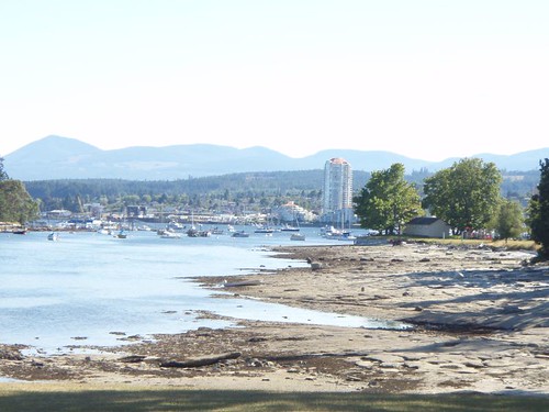
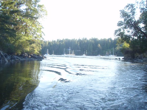
The bay is on the east side of two islands (Thetis Is. & Kuper Is.) These two islands are divided by a very narrow, very shallow water way called “The Cut”. On the other side of The Cut is Telegraph Harbor. The Cut is actually pretty wide, but there is a very narrow section through the middle of it that you could get a dinghy through or very small motor boat. The picture below was taken as we were just getting to the Telegraph Harbor end of the cut in the Dinghy, looking west.

Once on the other side, we stopped and got some ice cream and beer. We did’nt do much else in Clam Bay. In fact we just lounged around the boat once we got back.

Map of trip

Posted in Adventures, Big trips, Canada Trip, CB, Maps, Palarran | Leave a comment

Big trip to Canada. Day 23

Sunday August 3rd:

Today was AWESOME!!

We woke up to a sun shiny day. We pulled the anchor and headed out of Secret Cove around 7:30am or so. There was no wind so we decided to motor through Welcome Passage  and once past Pirate Rock and had b-fast we would raise some sail and head towards Nanimo on the other side of the Straights of Georgia.

As I mentioned before, the day started off nice and only got better. As we motored past Pirate Rock and started hoisting the mainsail and foresail, the wind picked up to about 8-10 knotsout of a clear blue sky to the north, we took that as a good omen and hoisted our third sail the Yankee (The Donger).  As the day wore on, the wind kept increasing to about 20 knots. But since the wind only started at about the same time we did, the waves had not had the chance to build. So we were abolutly hauling ass across the Straights on a broad reach.

As the wind picked up a little more and gusting even higher, we decided to drop the Yankee sail. By now we had 3 – 4 foot waves and were doing a very little bit of surfing down some of the bigger ones. Unless you sail, there is no way to describe how fun this is, the whole thing. Wind, waves, weather, the unknown…It’s just awesome.

We took the next two videos about 3/4 of the way across the Straights of Georgia. They of course in no way show just how fast we were going, or how the boat would surf down the waves. Or how hard the wind was blowing. But trust me….it as absolutly a blast!! Probably my best day sailing to date.

Look out! Cappy CB at the helm!

What we thought would be a 4 hour trip over, only ended up taking us a little over 2 hours. We were in Nanimo and anchored just after lunchtime.

Of course, all that wind on the way over meant that there would be wind in the anchorage as well. And it did make for a few anchoring “discussions” between me and Tawn :P , but before long we were settled in and checking out the town and the historical island before too long.

One other thing we wanted to check out while we were here was a bar called the Dinghy Dock, which turned out to be a very cool little place. Really the only way to get to it is by dinghy or small boat.

Two bars in two days!! Holy crap, we are out of control!!

We did a little hiking in the state park island here and checked out downtown a little as well. The picture below was taken from the island looking back across the bay the boat was anchored in to downtown Nanimo.

Of course it was back to the Dinghy Dock for a few cocktails to close the place down.

The big plan for tommorow is to get directions to a sunken battleship and go scuba diving on it tommorow.

Map of the trip

Posted in Adventures, Big trips, Canada Trip, CB, Maps, Palarran | Leave a comment