Big Trip to Canada. Day 7 (CB)

Saturday July 19th Saturday:

I can’t remember now exactly what time the alarm went off, it was definetly before 6 am. Maybe even before 5am. Either way, it was early. But at least we didn’t have to haul up the anchor, washdown and stow the anchor chain and anchor bouy. We were tied to mooring ball, so all we had to do was untie a mooring line and take off.

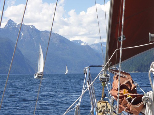
Ghost and WindDancer were up and motoring towards Malibu rapids as we came up on deck and started getting things ready to go. They went around the north side of MacDonald Island, we went around the South side. Through the rapids with ease and out into Queens Reach. Unfortunatly, there was absolutly no wind. So we had to motor most of the way. As we got to Nelson Island the winds picked up a little and we put the sails up for the last 10 miles of the trip. Ghost and WindDancer motored on and soon turned the corner around the island and out of site.

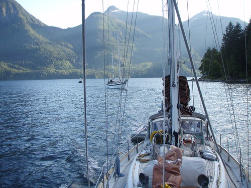
Our destination for today was a small cove on Hardy Island called Musket Cove. The entrance was nice and deep and well marked, as long as you were actually in the main channel and did’nt get suckered in to taking what appears to be a shortcut. Ghost was anchored and running there Stern line to shore as we entered the bay. WindDancer was doing the same.

Stern tieing is an anchoring technique used alot up here in BC. The main reason it is used so much is that alot of the anchorages up here are small little coves with very steep shores. If some one was to anchor regularly you could only get 2-3 boats in a small cove. If everyone stern ties, you could get 15 or more boats in the same cove. The reason is since your boat is tied to shore you cannot swing on your anchor. You stay in the same position no matter what the wind or tide is doing.

This would be our first time stern tieing.  And to be honest, I had sorta been worrying about it. Palarran is a full keeled boat, which means that she does not like to back up. Not without a fight, so I had imagined all sorts of crazy ass scenerios unfolding as I tried to keep the boat in one spot as Tawn took the stern line to shore. None of which happened.

I’ll try to explain the operation as best as I can.

Once we entered Musket cove we drifted for abit, getting everything ready to go. Get the anchor setup, get the engine on the dinghy, get the sternline untied and ready to hand overboard to Tawn. Once all that is set, we motored around the Anchorage looking for a good spot to anchor. We found one in the Northwest corner of the cove. I motored the boat up as close as I dared to the shore, depth sounder showed 18 feet, I spun the boat around and headed about 100 feet out from shore and Tawn dropped the anchor in 35 feet of water. As soon as Tawn tells me there is enough anchor chain out and the anchor is on the bottom, I put the engine in reverse and start backing up, towards the shore. Tawn is letting out more chain as we do this. When about 90 feet of  chain is out, Tawn stopped letting out the chain and we let the anchor dig in. This is the normal technique and we do it all the time.

Now comes the new bit. Running the stern line to shore and back. Once the anchor is set, Tawn jumps in the dinghy and I hand here one end of the stern line. The other end is wrapped around a big spool I built and mounted on the back of the boat. As Tawn is headed to shore, I’m paying out more and more line (we have 600ft total on the spool). Once she gets to shore, she climbs up and finds a tree and runs the rope around it. As she is doing this, I am on the boat, keeping it in place or making sure we dont drift into other boats or rocks on shore. She then pulls as much line as she thinks she needs to get back to the boat, where she hands me the line and I tie it off to the boat. We pull the line tight and that is about it. We are now anchored in a little corner of the bay and tied off to shore.

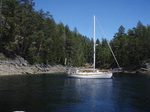
I of course took a few pictures of the final result. This first picture was taken right off the back of the boat. You can see the blue line running to shore, around the tree and back to the boat.

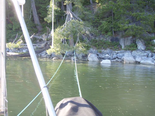
This next picture shows just how close to shore we were anchored and the blue line running to shore and back. But it showes that you can really tuck your boat into some very small spots and tie you self in and out of some nasty weather.

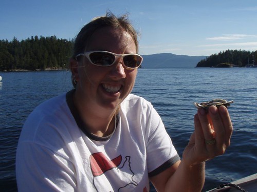
Once settled in we did a little dinghy exploring. Scotty lost an oar and we found a bunch of oysters.

Map of the trip.

Posted in Adventures, Big trips, Canada Trip, CB, Palarran, Tawn | Leave a comment

Big Trip to Canada. Days 4 – 6 (CB)

Wednesday – Friday July 16th – 18th:

The next couple days were spent either hanging out on the boats relaxing, hiking and exploring on shore, or swimming and exploring the Inlet by dinghy.

A very good portion of the first of those next couple days was actually spent in the hammock. After 3 days of getting up early and covering sorta long distances it felt good to do very little but drink some cold beers and lay in the hammock or dive overboard for a swim then back up in the hammock.

One of the things we wanted to do here was to hike up to the “Trapper’s Cabin”. All the guide books say that to hike up to this cabin is a suicide 3 hour one way mission up hill fighting bears the whole way. Me and Tawn say bullshit! So did scotty. The main reason we called bullshit was due to the fact that most of the “Cruising Guidebooks” are written by old people that don’t hike much past the docks. The rest of the information in the books are spot on, but when it comes to stuff like the condition of a hiking trail, I’m not going to heed the warnings of someone that is worried about breaking a hip.

So…off we went. Granted the hike was strenous, doubly so since we had spent the last 3 days sitting on a boat. But we made it up there in less than an hour and a half. And what did we get as a reward:

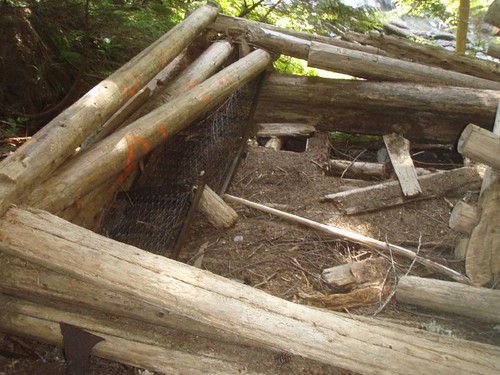
Basically an old pile of logs. You could make out the rough outline of a the old cabin, but it’s been here since the 1920s or 30s, so I guess it’s in pretty good shape considering. It was still pretty cool the have made the hike and check it out. Plus right next to the cabin was an awesome waterfall with a very cool view of the whole inlet about 2000 feet below.

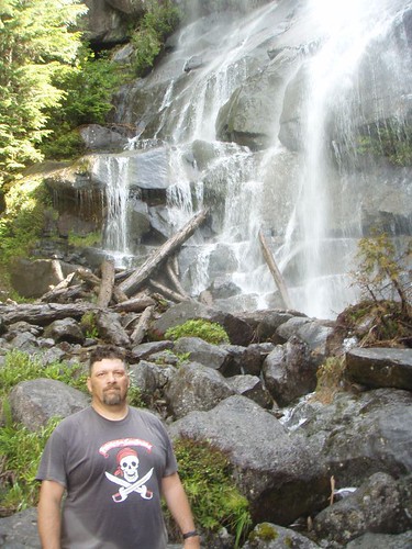
You can just feel the excitement of seeing that cabin in the expression on my face.

But the waterfall and view of the inlet more than made up for it. While Scotty, Tawn and myself were hiking up to the Trapper’s Cabin, Angie, Curtis, Cynthia and the Kids all took a dinghy ride back up the the entrance of Princess Louisa Inlet to the Lodge that sits right at the Malibu Rapids. The lodge is a Christian Summer camp and they will give you tours of the place if you show up. Those religous folks are so nice!

The lodge was actually started as a very fancy retreat for hollywood stars way back in the 1940s, but it’s a Jebus camp now.

You can just make out the Lodge way off in the distance in the picture below we took from the falls:

As unbelievable as it seems, the water tempatures here are actually up near the 70 degree mark. So we did a lot of swimming. Which is not something we can do off the boat back home, not without risking hypothermia at least. It was pretty nice to be able to just dive of the boat into the water or take the dinghy to a giant cliff and climb up and then jump off into warm water.

All things considered, Princess Louisa was probably our favorite spot on the whole trip. The rest was awesome, but Princess Louisa Inlet really topped them all.

On one of the nights Tawn, Scotty, Curtis and Myself jumped in two dinghies, tied them togather, tossed in a couple bottles of scotch and drifted down the bay telling stories and jokes as the current pulled us towards the rapids. We were’nt moving very fast of course and we just hungout watching the moon, which was full and very bright light up the inlet by reflecting off the granite cliffs on the North side of the inlet. We could not see the moon it’self because of the mountains to the south of us. What a cool night.

And as hard as it was to leave, we still wanted to see all the other places north, so we planned on leaving on Saturday morning. Early, since we had to time the tides once again to be able to get through Malibu Rapids again. Curtis had the idea to pull up anchor and move the boats a few miles closer to the rapids so we didn’t have to get up as early and could sleep in at least alittle longer. So Friday afternoon we all pulled up the anchor and moved down to McDonald Island and grabbed a Mooring ball for the night.

Posted in Adventures, Big trips, Canada Trip, CB, Palarran, Tawn | Leave a comment

Big Trip to Canada. Day 3 (CB)

Tuesday July 15th:

Map to the trip is here. The route today is outlined in green.

Ok, today is the day that the “vacation” actually felt like it started. The previous two days were travel days and felt like we were on a mission to get somewhere. Now that we made it, we could slow down and enjoy the sights.

And man, what sights!!

The day started off, with us following Ghost out of Pender Harbor. Winddancer would follow about an hour or so later, as they were going to fill up their fresh water tanks. We motored out of of Pender Harbor and turn north to head up Agamemnon Channel a couple minutes later the wind picked up and we were engines off and sailing.

As we approached Earls Cove there were some ancient Pietraglyphs (sp?) that were painted on the cliffs thousands of years ago and still visible. We could see them with our binoculars, but could not get a good picture with our camera.

As we were sailing toward Princess Louisa Inlet the wind would follow us around the ‘corners’. If you look on the map of the trip, you can see that the route up is a zigzag of four reaches. Everytime we would come to a new reach, we thought the wind would either die or change directions for the worse on us. But at each turn, the wind would simply follow us around the corner. Or we would flow with it, depending on how you look at it. The distance length wise of these 4 reaches is around 35 miles, but only a mile wide on average. The mountains drop straight down into the water. At one point we sailed right up to the cliff. Or at least within 20 feet of the side of the cliff and the depth sounder was reading over 600 feet of water!! And the cliff shot up another 3,000 feet or more. Unbelievable!! I could almost reach out and touch the wall as we sailed by before we gybed out again. I didn’t think to take a picture straight up.

Actually, none of the picture actually do any sort of justice, but we tried. This pic was taken about a mile or two after we sailed up to the cliff:

The rest of the day only got better. The winds got better and stayed on our stern and built to 20 knots. Just an awesome sail! As we rounded Patrick Point the wind just died. Completly. So we dropped the sails and motored the last mile or two to the begining of Malibu Rapids.

Malibu Rapid is the entrance to Princess Louisa Inlet (follow the link and read the wiki article if you want more info on the inlet) is known and named for the rapids that form when the tides change and all that water is trying to either get in or get out of the inlet. People actually white water kayak on the rapids that form here. No way in hell you could take a sailboat through here, unless you time it just right (Scotty ;P) and go through at just the right time. Which we did.

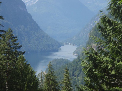
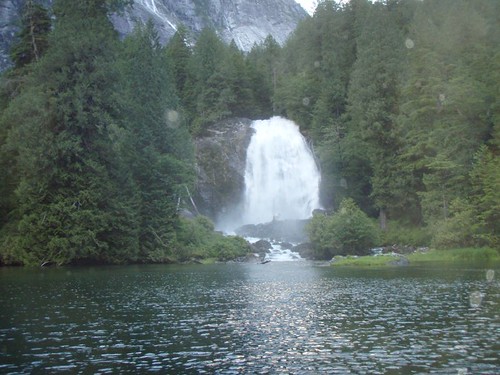
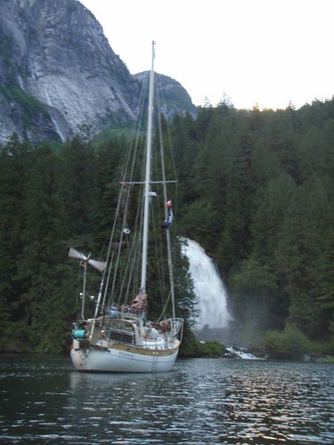
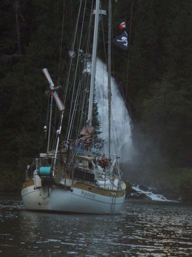
The entrance is only wide enough for one boat to pass at a time. So you have to make a call on the radio to signal your intent to enter and go for it. It is sorta dog legged, so you can see all the way through. Once through though, the scenery is unbelievably more impressive than that of the incredible views we had all day on the way up.

This picture makes it look like there is a lot of room, but just below the surface of the water are huge boulders and the shore that you have to follow a small channel through. You can see Ghost behind us winding thier way in.

The mountains are just as high as the reaches we had been sailing up all day, and drop straight down to the water, but the width of the inlet is 1/4 or less, so the effect is magnified. It’s like being in the bottom of a canyon. And to top it off, at the end of the inlet is Chatterbox Falls.

And where did we anchor?

I Love this next picture:

Anchoring there was crazy, we motored right up to the shore. Maybe 20 feet from it, and dropped the anchor in about 25 feet of water. Let out 100 feet of anchor chain and the water flowing out from the falls held us off the shore and pointed just like the picture showes for the 3 days we stayed there.

**{I’ve got a cool video we took of us motoring up to the shore and dropping the anchor. I plan to upload it tonight after work}**

Ok, so the video below is about 5 minutes long and not very exciting. But we started recording as we slowly motored in towards the shore. The camera was mounted on the bowsprite of the boat. The boat you see off to the right is our friends boat WindDancer. When the camera starts shaking and all the rattling is Tawn dropping the anchor and chain overboard.

I’m going to just stop even trying to discribe how incredible the scenery here is.

Stay tuned, tomorrow we actually go to shore and walk!!!

Posted in Adventures, Big trips, Canada Trip, CB, Maps, Palarran, Tawn | Leave a comment

Big Trip to Canada. Day 2 (CB)

Monday July 14th:

If your following along on the Map, the blue line is the route for day two.

In order to meet up with Ghost and Winddancer in Pender Harbor, we had another long day ahead of us. If it had not been for the fact that our route was taking us through Porlier Passage we could have gotten up whenever we wanted and just reached our destination a little later. But Slack tide at the pass was at 8:14am, which meant we had to be up and moving by 5am. This is a horribly early time normally, but on vacation it is doubly so.

Our usual plan of attack on early days like this is to get up, start the engine, raise the anchor and get moving. Then while underway we will make B-fast and coffee. That lets us sleep just that much longer. Actually that is the plan on all days, early or not.

The trip through the Gulf Islands was fairly univentful. There was not a breath of wind. But it was sunny and warm, and there was lots to look at. It seemed like a shame to be blasting through without stopping to check out any of the places we were passing by, but we would be coming back this way at the end of the month. So it was’nt too bad.

We got to Polier Passage at about 8:30, so we missed slack tide but the tide was flooding which meant it would be going the same direction we were. Polier Passage is not too narrow, but the amount of water that flows through can get the tide moving up to nine knots at times and the whole passage is littered with hidden rocks. This makes going through at slack water or as close to it as you can a pretty good idea.

Once through the passage and out into the Straights of Georgia the wind was blowing out of the north west at about 15-17 knots. With the pass behind us we decided to do some sailing, even if it meant getting to Pender Harbor a little later than planned.

**{I have video of a small bit of the sailing we did, but I can’t seem to get it edited correctly to post it up here. I’ll work on it and hopefully get it posted soon.}**

We had maybe an hour or two of good sailing, but the wind died just as we reached Thrasher Reef, and with a name like Thrasher Reef, it might be a good idea to have the engine on as we passed through it.

Once on the other side of the reef the wind completly died and left us with a freaking awesome sunny day, but no wind. So with the sails down, we continued north under power.

I can’t recall the exact time we got to Pender Harbor, it must have been about 4-5pm. At any rate we negoiated the narrow rock strewn entrance and found our way all the way back to Garden Bay where we spotted Ghost and Winddancer rafted together. We had spoke with Curtis (from Winddancer) on the radio a little earlier and he let us know they were working on a small engine problem on Ghost and for us to anchor out on our own.

Garden Bay

We circled their raft up, catching up on a few small bits of stuff then proceeded to find a good place to drop the anchor. Garden Bay it’self is pretty small, and at this time of day it was pretty full. The weather forecast was calling for calm weather tommorow, so we decided to anchor outside of Garden Bay in Pender Harbor. Which is still very protected.

Once anchored we dinghied over to the raft up for hugs, handshakes, beers and some catching up. Ghost had been out for 2 weeks already so they had stories to tell and they wanted to hear about our trip up. Winddancer had a few tales to tell as well.

Originally we thought we would stay in Garden Bay for a day and stock up the fridge, but we had loaded up so well in Seattle before we left we only needed a few items (Ice and fresh Veggies). We decided to get up in the morning and head further north.

Scotty, Curtis and myself decided to head to shore to the IGA and get some stuff before dinner. Tommorrow would be about half as long a day as the previous two. We only had one major obsticle to cross. Malibu Rapids. This absolutly had to be crossed at the right time, which was in the evening. So we planned to leaving our around 11am. Which was fine with us, since we were tired of getting up so friggin early.

Posted in Adventures, Big trips, Canada Trip, CB, Maps, Palarran, Tawn | Leave a comment