Tuesday July 15th:
Map to the trip is here. The route today is outlined in green.
Ok, today is the day that the “vacation” actually felt like it started. The previous two days were travel days and felt like we were on a mission to get somewhere. Now that we made it, we could slow down and enjoy the sights.
And man, what sights!!
The day started off, with us following Ghost out of Pender Harbor. Winddancer would follow about an hour or so later, as they were going to fill up their fresh water tanks. We motored out of of Pender Harbor and turn north to head up Agamemnon Channel a couple minutes later the wind picked up and we were engines off and sailing.
As we approached Earls Cove there were some ancient Pietraglyphs (sp?) that were painted on the cliffs thousands of years ago and still visible. We could see them with our binoculars, but could not get a good picture with our camera.
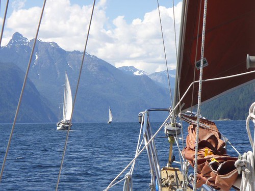
As we were sailing toward Princess Louisa Inlet the wind would follow us around the ‘corners’. If you look on the map of the trip, you can see that the route up is a zigzag of four reaches. Everytime we would come to a new reach, we thought the wind would either die or change directions for the worse on us. But at each turn, the wind would simply follow us around the corner. Or we would flow with it, depending on how you look at it. The distance length wise of these 4 reaches is around 35 miles, but only a mile wide on average. The mountains drop straight down into the water. At one point we sailed right up to the cliff. Or at least within 20 feet of the side of the cliff and the depth sounder was reading over 600 feet of water!! And the cliff shot up another 3,000 feet or more. Unbelievable!! I could almost reach out and touch the wall as we sailed by before we gybed out again. I didn’t think to take a picture straight up.
Actually, none of the picture actually do any sort of justice, but we tried. This pic was taken about a mile or two after we sailed up to the cliff:
The rest of the day only got better. The winds got better and stayed on our stern and built to 20 knots. Just an awesome sail! As we rounded Patrick Point the wind just died. Completly. So we dropped the sails and motored the last mile or two to the begining of Malibu Rapids.
Malibu Rapid is the entrance to Princess Louisa Inlet (follow the link and read the wiki article if you want more info on the inlet) is known and named for the rapids that form when the tides change and all that water is trying to either get in or get out of the inlet. People actually white water kayak on the rapids that form here. No way in hell you could take a sailboat through here, unless you time it just right (Scotty ;P) and go through at just the right time. Which we did.
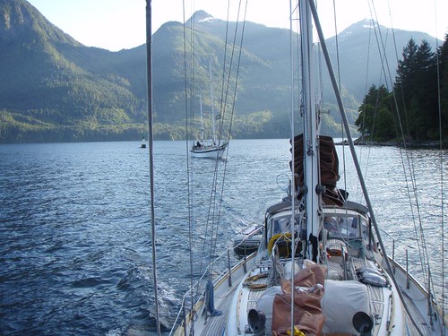 The entrance is only wide enough for one boat to pass at a time. So you have to make a call on the radio to signal your intent to enter and go for it. It is sorta dog legged, so you can see all the way through. Once through though, the scenery is unbelievably more impressive than that of the incredible views we had all day on the way up.
This picture makes it look like there is a lot of room, but just below the surface of the water are huge boulders and the shore that you have to follow a small channel through. You can see Ghost behind us winding thier way in.
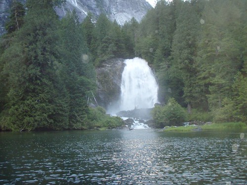
The mountains are just as high as the reaches we had been sailing up all day, and drop straight down to the water, but the width of the inlet is 1/4 or less, so the effect is magnified. It’s like being in the bottom of a canyon. And to top it off, at the end of the inlet is Chatterbox Falls.
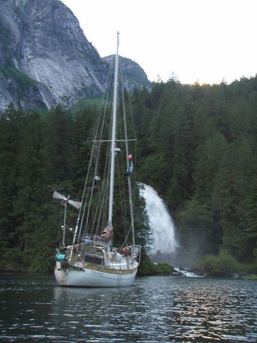
And where did we anchor?
I Love this next picture:
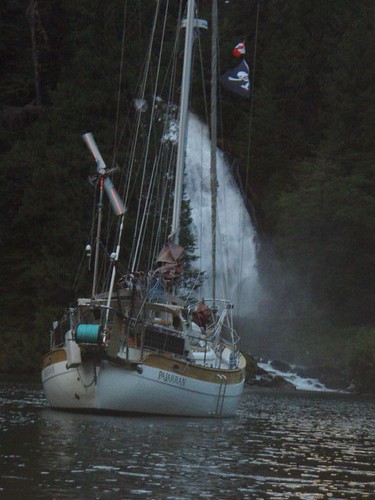
Anchoring there was crazy, we motored right up to the shore. Maybe 20 feet from it, and dropped the anchor in about 25 feet of water. Let out 100 feet of anchor chain and the water flowing out from the falls held us off the shore and pointed just like the picture showes for the 3 days we stayed there.
**{I’ve got a cool video we took of us motoring up to the shore and dropping the anchor. I plan to upload it tonight after work}**
Ok, so the video below is about 5 minutes long and not very exciting. But we started recording as we slowly motored in towards the shore. The camera was mounted on the bowsprite of the boat. The boat you see off to the right is our friends boat WindDancer. When the camera starts shaking and all the rattling is Tawn dropping the anchor and chain overboard.
I’m going to just stop even trying to discribe how incredible the scenery here is.
Stay tuned, tomorrow we actually go to shore and walk!!!