Big Trip to Canada. Day 3 (CB)

Tuesday July 15th:

Map to the trip is here. The route today is outlined in green.

Ok, today is the day that the “vacation” actually felt like it started. The previous two days were travel days and felt like we were on a mission to get somewhere. Now that we made it, we could slow down and enjoy the sights.

And man, what sights!!

The day started off, with us following Ghost out of Pender Harbor. Winddancer would follow about an hour or so later, as they were going to fill up their fresh water tanks. We motored out of of Pender Harbor and turn north to head up Agamemnon Channel a couple minutes later the wind picked up and we were engines off and sailing.

As we approached Earls Cove there were some ancient Pietraglyphs (sp?) that were painted on the cliffs thousands of years ago and still visible. We could see them with our binoculars, but could not get a good picture with our camera.

As we were sailing toward Princess Louisa Inlet the wind would follow us around the ‘corners’. If you look on the map of the trip, you can see that the route up is a zigzag of four reaches. Everytime we would come to a new reach, we thought the wind would either die or change directions for the worse on us. But at each turn, the wind would simply follow us around the corner. Or we would flow with it, depending on how you look at it. The distance length wise of these 4 reaches is around 35 miles, but only a mile wide on average. The mountains drop straight down into the water. At one point we sailed right up to the cliff. Or at least within 20 feet of the side of the cliff and the depth sounder was reading over 600 feet of water!! And the cliff shot up another 3,000 feet or more. Unbelievable!! I could almost reach out and touch the wall as we sailed by before we gybed out again. I didn’t think to take a picture straight up.

Actually, none of the picture actually do any sort of justice, but we tried. This pic was taken about a mile or two after we sailed up to the cliff:
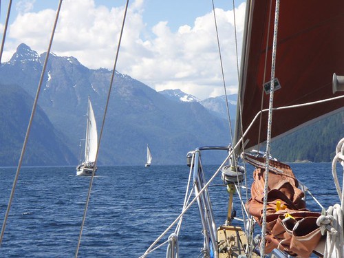
The rest of the day only got better. The winds got better and stayed on our stern and built to 20 knots. Just an awesome sail! As we rounded Patrick Point the wind just died. Completly. So we dropped the sails and motored the last mile or two to the begining of Malibu Rapids.

Malibu Rapid is the entrance to Princess Louisa Inlet (follow the link and read the wiki article if you want more info on the inlet) is known and named for the rapids that form when the tides change and all that water is trying to either get in or get out of the inlet. People actually white water kayak on the rapids that form here. No way in hell you could take a sailboat through here, unless you time it just right (Scotty ;P) and go through at just the right time. Which we did.
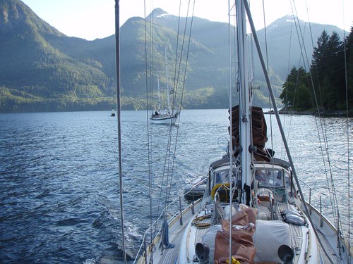
The entrance is only wide enough for one boat to pass at a time. So you have to make a call on the radio to signal your intent to enter and go for it. It is sorta dog legged, so you can see all the way through. Once through though, the scenery is unbelievably more impressive than that of the incredible views we had all day on the way up.

This picture makes it look like there is a lot of room, but just below the surface of the water are huge boulders and the shore that you have to follow a small channel through. You can see Ghost behind us winding thier way in.

The mountains are just as high as the reaches we had been sailing up all day, and drop straight down to the water, but the width of the inlet is 1/4 or less, so the effect is magnified. It’s like being in the bottom of a canyon. And to top it off, at the end of the inlet is Chatterbox Falls.
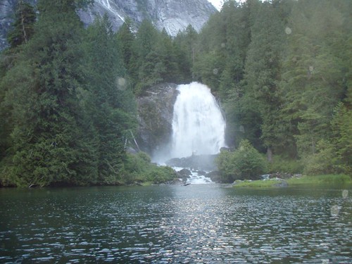
And where did we anchor?
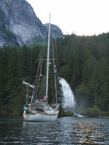
I Love this next picture:
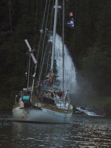
Anchoring there was crazy, we motored right up to the shore. Maybe 20 feet from it, and dropped the anchor in about 25 feet of water. Let out 100 feet of anchor chain and the water flowing out from the falls held us off the shore and pointed just like the picture showes for the 3 days we stayed there.

**{I’ve got a cool video we took of us motoring up to the shore and dropping the anchor. I plan to upload it tonight after work}**

Ok, so the video below is about 5 minutes long and not very exciting. But we started recording as we slowly motored in towards the shore. The camera was mounted on the bowsprite of the boat. The boat you see off to the right is our friends boat WindDancer. When the camera starts shaking and all the rattling is Tawn dropping the anchor and chain overboard.

I’m going to just stop even trying to discribe how incredible the scenery here is.

Stay tuned, tomorrow we actually go to shore and walk!!!
Posted in Adventures, Big trips, Canada Trip, CB, Maps, Palarran, Tawn | Leave a comment

Big Trip to Canada. Day 2 (CB)

Monday July 14th:

If your following along on the Map, the blue line is the route for day two.

In order to meet up with Ghost and Winddancer in Pender Harbor, we had another long day ahead of us. If it had not been for the fact that our route was taking us through Porlier Passage we could have gotten up whenever we wanted and just reached our destination a little later. But Slack tide at the pass was at 8:14am, which meant we had to be up and moving by 5am. This is a horribly early time normally, but on vacation it is doubly so.

Our usual plan of attack on early days like this is to get up, start the engine, raise the anchor and get moving. Then while underway we will make B-fast and coffee. That lets us sleep just that much longer. Actually that is the plan on all days, early or not.

The trip through the Gulf Islands was fairly univentful. There was not a breath of wind. But it was sunny and warm, and there was lots to look at. It seemed like a shame to be blasting through without stopping to check out any of the places we were passing by, but we would be coming back this way at the end of the month. So it was’nt too bad.

We got to Polier Passage at about 8:30, so we missed slack tide but the tide was flooding which meant it would be going the same direction we were. Polier Passage is not too narrow, but the amount of water that flows through can get the tide moving up to nine knots at times and the whole passage is littered with hidden rocks. This makes going through at slack water or as close to it as you can a pretty good idea.

Once through the passage and out into the Straights of Georgia the wind was blowing out of the north west at about 15-17 knots. With the pass behind us we decided to do some sailing, even if it meant getting to Pender Harbor a little later than planned.

**{I have video of a small bit of the sailing we did, but I can’t seem to get it edited correctly to post it up here. I’ll work on it and hopefully get it posted soon.}**

We had maybe an hour or two of good sailing, but the wind died just as we reached Thrasher Reef, and with a name like Thrasher Reef, it might be a good idea to have the engine on as we passed through it.

Once on the other side of the reef the wind completly died and left us with a freaking awesome sunny day, but no wind. So with the sails down, we continued north under power.

I can’t recall the exact time we got to Pender Harbor, it must have been about 4-5pm. At any rate we negoiated the narrow rock strewn entrance and found our way all the way back to Garden Bay where we spotted Ghost and Winddancer rafted together. We had spoke with Curtis (from Winddancer) on the radio a little earlier and he let us know they were working on a small engine problem on Ghost and for us to anchor out on our own.

Garden Bay

We circled their raft up, catching up on a few small bits of stuff then proceeded to find a good place to drop the anchor. Garden Bay it’self is pretty small, and at this time of day it was pretty full. The weather forecast was calling for calm weather tommorow, so we decided to anchor outside of Garden Bay in Pender Harbor. Which is still very protected.

Once anchored we dinghied over to the raft up for hugs, handshakes, beers and some catching up. Ghost had been out for 2 weeks already so they had stories to tell and they wanted to hear about our trip up. Winddancer had a few tales to tell as well.

Originally we thought we would stay in Garden Bay for a day and stock up the fridge, but we had loaded up so well in Seattle before we left we only needed a few items (Ice and fresh Veggies). We decided to get up in the morning and head further north.

Scotty, Curtis and myself decided to head to shore to the IGA and get some stuff before dinner. Tommorrow would be about half as long a day as the previous two. We only had one major obsticle to cross. Malibu Rapids. This absolutly had to be crossed at the right time, which was in the evening. So we planned to leaving our around 11am. Which was fine with us, since we were tired of getting up so friggin early.

Posted in Adventures, Big trips, Canada Trip, CB, Maps, Palarran, Tawn | Leave a comment

The Big Trip to Canada! Day 1 (CB)

We have, in one way or another been planning this trip for a year, almost since the day we got back from last years vacation to the San Juan Islands. Maybe even before we got back. I use the word “planning” loosely. The main idea behind the trip was no schedules to speak of. Just a month off, on our boat, sailing between Seattle and Desolation Sound in British Columbia, Canada.

Some fun facts from the trip, we were gone for about 30 days (July 13th – Aug 13th).

  • Covered a grand total of 580+ miles (using less than 70 gallons of fuel).
  • We took 300+ pictures (which can be found by clicking here) and over 20 short videos (Which I plan to edit togather and post up here at sometime in the near future).
  • Drank a lot of really shitty, really expensive Canadian Beer (Sorry Canada, I just call it like I see it).
  • Saw some amazing sites and got some incredible sailing in.

All in all, the best vacation We’ve ever been on.

As per usual, i’ve created a map on Google maps so you can follow along. I’ve placed icons at the locations that I mention in the text and underlined. I think it will help you get a better idea of where all this is taking place at in the world.


View Larger Map

Here is the story, as I recall it:

DAY 1 July 13th

As I mentioned before, we did’nt really have a set schedule of places to go, or things to see. We had a rough idea of where we wanted to go and a few ‘must see’ places that we had either heard about or read about. We did however want to get as far north as possible in the first couple days of the vacation so we could slow down and slowly work our way home. As opposed to taking out time up and having to haul ass home as the vacation came to a close.

So with that as a rough outline for the trip, as soon as I got home from my last day at work. I went straight to bed (7pm). The idea was that I would get up at midnight, which was about a half hour before high tide. We would get the boat ready and leave, riding the tide as it ebbed out of Puget Sound. This basically speeds our boat up. Just like how a plane can fly faster if the wind is behind it. The tide carries us along with it.

As I was much to excited to really sleep, I got up at about 11:30pm and started getting things ready. Tawn had not gone to bed, since she would go to sleep as soon as we left the dock and I would wake her up around 4am for her watch.

Leaving the marina in the middle of the night was very cool. As we left the north entrance of the marina the bonfires on the beach at Golden Gardens Park were dieing down as the cops were kicking the people out of the park. Including the stoned mofos in the drum circle.

Once out of the marina, there was absolutly no wind. The moon was about 3 days from being full, so you could see pretty well. Tawn went below to get some sleep. I had a cup of mocha and a Thermos full of beef stew. My first night watch was pretty uneventful. Flat calm water and tide with us, we flew north. Making way better time that I thought we would.

I wasn’t really paying attention to the time and was sorta enjoying myself when I realized that the sky was lighting and the sun was coming up. At about 5am we passed Marrowstone Point and I could see Port Townsend about 3 knots to the west. I was just about to duck below to wake up Tawn, but noticed a really slow moving, and very big wave moving towards me. Not a wave, in the surfs up sort of wave. But a large rolling wave. I thought it seemed odd since there were no other waves at all. As the wave passed under the boat, I noticed more and more of them and then realized we were coming up to the notorious Point Wilson tide rips.

Tawn had woken up on her own and came up on deck. We talked for abit and got to talking about the waves that by now were really building. The wind was also picking up from the west. In the space of 10 minutes, we went from absolutly no wind and flat calm seas to 25 knots of west wind and 10-12 foot seas. The waves were crazy and confused. There was no rythmn to them. They would pop up and slam the boat from every direction.

The reason for this is that Point Wilson is the point that Puget Sound (Admirality Inlet) and the Straights of Juan De Fuca meet. Point Wilson is also a fairly shallow point. So all the water that had been flowing out of Puget Sound with the tides all night (us with it), hits the waves that are created by the west wind that had been blowing down the Straights of Juan De Fuca all night. Imagine a gutter, then taking two buckets of water. One at each end of that gutter and pouring the water from each end at the same time. Now imagine being a ant on a small bit of leaf in the middle where the water meets…..That was us.

Any way, sails up and I went to bed. But not before getting sea sick for some reason. So a quick toss of the cookies over the leeward rail then back to bed. :)

A couple hours later I woke up and came up on deck. The sun was out, the wind had died to almost nothing, but we were left with some roly poly waves. This was just south of Lime Kiln Point on the SW side of San Juan Island. We entered Bedwell Harbor and tied up to the customs dock so we could check into Canada at approx 1pm on Sunday afternoon.

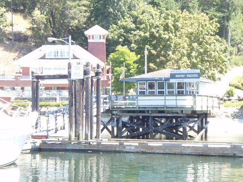
Canadian Customs dock in Bedwell Harbor

For some reason, I had been worried about clearing into Canadian customs. We’ve done a crap load of times by car, but never by boat. I’m not really sure what I was worrying about. The questions are the same, but for some reason I had thought that we would have brought to much of the wrong type of food (which we did’nt) or to much booze (which we did). But to my surprise and relief, they did’nt give a shit. We got our clearance number and away we went.

In this case, “away we went” did’nt actually amount to that great a distance. We just motored about 1/4 mile away and anchored in the bay. It was a nice sunny day, the wind had picked up. We found our spot in the anchorage and dropped the hook. Ate a little bit of food and started to read a book. Next thing I know, it’s 3 hours later and I’m drooling. I guess I was more tired than I thought. We did’nt even bother to put the dinghy in the water as we had to get up early the next day and head further north. We had to be at Porlier Pass by 8:30am so we could get through with the current.

More to follow…..

Posted in Adventures, Big trips, Canada Trip, CB, Palarran, Tawn | Leave a comment

Back to the land of pockets.

Ok, we are back home and back to work. We have a ton of pictures and some video we took on the trip. I have not uploaded any of the pictures to the web yet. I’ll get on that very soon.

In case your wondering what the “land of pockets” is (and I’m sure you are since it’s something retarded I made up a couple days ago). It’s a stupid realisation that I came to the first day we got back.

We got back home on Monday afternoon.  And after cleaning up the boat and doing a few other clean up things we decided to go over to some friends boat for drinks and dinner. But we needed some food to bring and some beer. So I volunteered to go do it. As I was stepping off the boat on to the dock. I realized I needed a few items:

  •  Jeep keys
  • Wallet
  • Cell Phone

None of these items had been used by me in the last month (well maybe the wallet, but only a few times). As I patted my pockets after retreiving them I realized that I had a habit of patting my pockets when I left the boat to make sure I had all the tools I needed to survive the urban terrian.

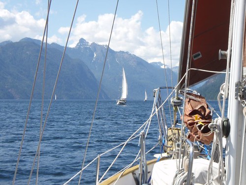
I did actually upload one picture from the trip. It was taken on the 3rd day of the vacation as we were headed up to Princess Louisa Inlet. The two boats ahead of us are our friends “Ghost” and “Wind Dancer”.

Headed to Princess Louisa Inlet

Posted in Adventures, Big trips, CB, Palarran, Tawn | Leave a comment